422946
- TitleSamuel Wallis - drawings made during the voyage of H.M.S. Dolphin, 1767
- Creator
- Call numberPXD 72
- Level of descriptionfonds
- Date
1767 - Type of material
- Reference code422946
- Issue CopyDigitised
- Physical Description1 album (12 drawings) - wash - largest 28.4 x 47 cm. (no. 1), smallest 14 x 28.4 cm. (no. 6b), most approx. 16 x 34 cm.
- Scope and ContentA letter dated 15th Nov. 1920 from Francis Edwards, bookseller, to H. Wright, Mitchell Library, outlining the previous ownership of the drawings, is tipped in at the beginning of the album. Each drawing is pasted onto backing paper which is pasted onto card and bound into album.
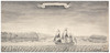
1. A Ground Plan; and Perspective View of the Queens House, at King Georges Island, Lying in Latd: 17:30S and Longitude of 150:00 West from London. This House is 327 feet Long and forty two feet Broad it is supported in the Middle by fourteen Pillars and Thirty Nine at the Sides, is thirty feet high in the Middle and Twelve feet high at the Sides. Discovered by his Majestys Ship Dolphin on the 24. of June 1767. Done by Sam: Wallis. 1767
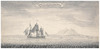
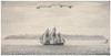
2a. The Earl of Egmonts Island, in Latd: 19[degrees]:20' S Long: 138:30 W of London
2b. A View of Queen Charlotts Island, Latd: 19[degrees] 18' S, Long: 138[degrees] [?] W
"Sam: Wallis June 1767" -- at lower right
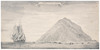
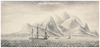
3. His Royl: Highness the Duke of Glocesters Island In Lat: 19: 11 S Long: 140:04 W from London
4. His Royal Highness the Duke of York's Island. Lying in Lat: 17:30 South, Long: 150:16 West from London
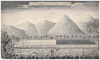
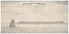
5. Wallis Island. in Latitude 13[degrees]: 18' South, and Long: 177:00 West from London. Variation 10.0. East
6a. Her Majesty Queen Charlotte's Isle
6b. Whitsunday Island Latitude 19[degrees]:26' S. Longd: 137[degrees]:56' W
"S: Wallis. June 1767"
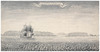
7. The Honb: Augustus Keppel's Island Lying in the Latitude of 15:54 S. Longd. 175:12 W from London.
"Aug. 13. 1767" -- in pencil beneath scroll
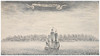
8. The Right Honbl: Lord Visc: Howes Island lying in Latd: 16:46. S. Longd: 154:13.W from London
9. Boscawens Isle. Latid: 15:50 S. Long 175:09. W-
"Aug 13. 1767" -- in pencil within scroll
10. His Roy: Highness the Duke of Cumberland's Island. Lat: 19:18 S. L.ong 140:36 West of London. / Roy: Highness Prince Wm: Henry Island. Latd: 19:00 S Longd: 140:06 West of London.
"5. & 6.'" -- in ink at upper left
"Saml: Wallis June 1767" -- at lower right - Copying ConditionsOut of copyright: Creator died before 1955
Please acknowledge:: Mitchell Library, State Library of New South Wales - Description source
Each work is titled within a scroll at top centre. - General note
Samuel Wallis' log on HMS Dolphin, 1766-1768, is located at Safe 1/98 (photocopy at CY Safe 1/98 - open access; microfilm copy at MAV/FM4/1355).
In the foreground of no. 1 is a horizontal line of 14 black points approx. 32 mm. apart, each circled in red. An arc of closely spaced red points from each end of this line meets the left and right walls of the house. The foreground markings may correspond to the 14 pillars supporting the middle of the house, representing the `ground plan' of the title. The red points appear to be applied on top of black. It is not known whether the markings in red are by Wallis or were added by a later hand to highlight the ground plan.
An unsigned pencil sketch, apparently based on no. 1 in this album, is tipped inside the back cover of a printed volume (DL Q77/30) formerly owned by Thomas Pennant, a scientist and friend of Joseph Banks: Hawkesworth, J., An account of the voyages undertaken by the order of His present Majesty, for making discoveries in the southern hemisphere, and successively performed by Commodore Byron, Captain Wallis, Captain Carteret, and Captain Cook, in the Dolphin, the Swallow, and the Endeavour (London: Printed for W. Strahan and T. Cadell ... , 1773), vol. 1. The sketch measures 7.8 x 12.4 cm. It is inscribed on the reverse in ink: `From a drawing by Captn. Wallis in Otaheite'.
Polynesian geographical names are as follows (in parentheses): King George's Island (Tahiti); Earl of Egmont's Island (Vairaatea); Queen Charlotte's Island (Nukutavake); Duke of Gloucester's Island (Paraoa); Duke of York's Island (Moorea); Wallis Island (Uvea); Whitsunday Island (Pinaki); Keppel's Island (Niuatoputapu); Lord Howe's Island (Maupihaa); Boscawen's Isle (Tafahi); Duke of Cumberland's Island (Manuhangi); Prince William Henry's Island (Nengonengo).
References: ML Pictures card catalogue; Columbia Gazetteer; www.oceandots.com
Digital order no:Album ID : 823617 - Signatures / Inscriptions
Unless otherwise noted, each work is signed "Saml: Wallis", "Sam: Wallis", or "S: Wallis" and dated 1767 at lower right.
"Oct. 1920" embossed in gilt on inside edge of album back cover - Name
- Subject
- Topic
- Place
- Exhibited in
Dare to know : the art and science of Pacific voyages - State Library of New South Wales (1 June - 28 November, 1998). Applies to: no. 1
Painting the Pacific - State Library of New South Wales (January 2002 - April 2002). Applies to: nos. 1 & 5
View Media Files
2. 
3. 
4. 
5. 
6. 
7. 
8. 
9. 
10. 
11. 
12. 
13. 
- Browse collection hierarchy
- Manuscript Index
- A
- B
- C
- D
- E
- F
- G
- H
- I
- J
- K
- L
- M
- N
- O
- P
- Q
- R
- S
- T
- U
- V
- W
- X
- Y
- Z